GeoIP Location: The Complete Guide to Digital Geolocation Technology
Introduction: The Digital Cartography Revolution
In the physical world, we navigate using street addresses, landmarks, and GPS coordinates. In the digital realm, a parallel system exists: GeoIP (Geolocation by Internet Protocol) technology. This sophisticated system maps IP addresses to real-world geographic locations, creating an invisible layer of geographic intelligence that powers everything from content personalization and fraud detection to cybersecurity and digital rights management. This comprehensive guide explores the mechanisms, accuracy, applications, and implications of GeoIP technology.
Section 1: Understanding GeoIP Fundamentals
What is GeoIP?
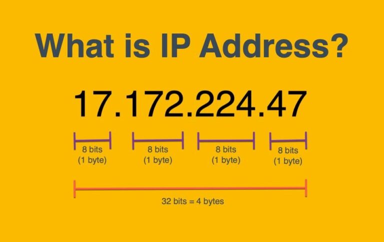
GeoIP is the process of determining the geographic location of an internet-connected device by analyzing its IP (Internet Protocol) address. Unlike GPS, which relies on satellite signals and provides precise coordinates, GeoIP offers probabilistic location data based on network infrastructure mapping.
Core Components of GeoIP Systems
1. IP Address Databases:
Static databases: Commercial (MaxMind, IP2Location) and free (IPinfo, DB-IP)
Dynamic databases: Continuously updated with new assignments and movements
Proprietary vs. open-source: Varying accuracy and coverage
2. Geolocation Methods:
Whois data: Registration information from Regional Internet Registries (RIRs)
BGP routing tables: Analyze how traffic routes through network backbones
Latency measurements: Time delays between known nodes and target IPs
DNS location records: Geographic hints in domain name system
WiFi/cellular tower mapping: For mobile IP localization
3. Confidence Scoring Systems:
Radius accuracy: Often expressed in kilometers/miles
Certainty levels: From country (high) to city/street (variable)
Multi-factor validation: Cross-referencing multiple data sources
Section 2: The Technical Architecture of GeoIP Systems
Data Collection Methodologies
Passive Data Collection:
ISP allocation data: Blocks of IPs assigned to specific regions
RIR records: AFRINIC, APNIC, ARIN, LACNIC, RIPE NCC maintain allocation databases
Network topology mapping: Analyzing how networks interconnect geographically
Volunteered data: Users opt-in to share location (some free databases)
Active Probing Techniques:
Traceroute analysis: Mapping network paths to infer location
Latency triangulation: Measuring ping times from multiple known locations
Network tomography: Inferring topology from partial measurements
Landmark-based geolocation: Using known server locations as reference points
Commercial Data Sources:
Carrier data: Mobile network operator information
Content Delivery Networks (CDNs): Edge server locations
VPN/Proxy detection: Identifying masking services
Device/browser data: When combined with IP for enhanced accuracy
Database Structure and Organization
Typical Database Fields:
IP Range Start: 192.168.1.0
IP Range End: 192.168.1.255
Country: United States
Country Code: US
Region: California
Region Code: CA
City: San Francisco
Postal Code: 94107
Latitude: 37.7749
Longitude: -122.4194
Time Zone: America/Los_Angeles
ISP: Example Internet Inc.
Connection Type: Cable
AS Number: 12345
Accuracy Radius: 10 km
Confidence Factor: 85%
Hierarchical Resolution Levels:
Continent-level: ~99% accuracy
Country-level: 95-99% accuracy
Region/State-level: 80-95% accuracy
City-level: 70-90% accuracy
Postal Code-level: 60-85% accuracy
Coordinates: 50-80% accuracy (highly variable)
Section 3: Accuracy Factors and Limitations
Variables Affecting GeoIP Accuracy
Network Infrastructure Factors:
ISP network design: Some ISPs route traffic far from actual users
Mobile carrier routing: Cellular traffic often routes through central hubs
Anycast routing: Same IP serves multiple geographic locations
Cloud and CDN usage: IPs map to data centers, not end users
Satellite internet: Often shows gateway location, not user location
Technical Limitations:
Dynamic IP assignment: Users change IPs, especially with DHCP
Network Address Translation (NAT): Multiple users share single IP
VPN and proxy services: Completely mask true location
TOR network: Intentionally obscures location through multiple hops
Database Limitations:
Update frequency: Daily, weekly, or monthly updates affect freshness
Coverage gaps: Better data for developed vs. developing regions
Business vs. residential: Different assignment patterns affect accuracy
IPv4 vs. IPv6: Newer protocol has different allocation patterns
Accuracy Statistics by Region
Typical Accuracy Metrics:
North America/Europe: 90-99% country-level, 70-85% city-level
Asia-Pacific: 85-95% country-level, 60-75% city-level
Africa/South America: 75-90% country-level, 50-65% city-level
Mobile networks: 5-50km accuracy radius typically
Quantitative Studies:
MIT Study (2011): Median error of 35km for U.S. residential IPs
University of Chicago Study: 50th percentile error ~25km, 90th ~100km
Industry reports: Commercial databases claim 99.8% country accuracy
Section 4: GeoIP Implementation Methods
Server-Side Implementation
Web Server Integration:
http {
geoip_country /usr/share/GeoIP/GeoIP.dat;
geoip_city /usr/share/GeoIP/GeoLiteCity.dat;
server {
location / {
add_header X-Country $geoip_country_code;
}
}
}Application-Level Integration:
import geoip2.database
reader = geoip2.database.Reader('GeoLite2-City.mmdb')
response = reader.city('128.101.101.101')
print(f"Country: {response.country.name}")
print(f"City: {response.city.name}")
print(f"Coordinates: {response.location.latitude}, {response.location.longitude}")
print(f"Accuracy: {response.location.accuracy_radius} km")Database Integration:
CREATE TABLE ip_locations (
ip_start INT UNSIGNED,
ip_end INT UNSIGNED,
country_code CHAR(2),
region VARCHAR(100),
city VARCHAR(100),
latitude DECIMAL(10, 8),
longitude DECIMAL(11, 8),
INDEX idx_ip_range (ip_start, ip_end)
);
SELECT * FROM ip_locations
WHERE INET_ATON('192.168.1.1') BETWEEN ip_start AND ip_end;Client-Side Techniques
JavaScript Implementation:
fetch('https://ipapi.co/json/')
.then(response => response.json())
.then(data => {
console.log(`IP: ${data.ip}`);
console.log(`City: ${data.city}`);
console.log(`Region: ${data.region}`);
console.log(`Country: ${data.country_name}`);
console.log(`Location: ${data.latitude}, ${data.longitude}`);
});
async function getGeoLocation() {
const services = [
'https://ipapi.co/json/',
'https://ipinfo.io/json',
'https://geolocation-db.com/json/'
];
for (const service of services) {
try {
const response = await fetch(service);
return await response.json();
} catch (error) {
continue;
}
}
throw new Error('All GeoIP services failed');
}Hybrid Approaches
IP + Browser/Device Data:
HTML5 Geolocation API: User permission required, high accuracy
Timezone detection: Intl.DateTimeFormat().resolvedOptions().timeZone
Language settings: navigator.language
Screen resolution/timezone: Additional context clues
Multi-source Correlation:
Primary: IP-based geolocation
Secondary: Browser timezone and language
Tertiary: Network latency measurements
Quaternary: WiFi access point data (when available)
Section 5: Applications and Use Cases
E-commerce and Retail
Regional Pricing and Offers:
Display prices in local currency
Show region-specific promotions
Comply with regional pricing regulations
Estimate shipping costs and times
Tax Calculation:
Automatically calculate sales tax/VAT
Determine tax jurisdictions
Generate region-compliant invoices
Support for tax-exempt regions
Inventory and Delivery:
Show product availability by region
Estimate delivery times
Route to nearest warehouse/distribution center
Localize packaging and instructions
Content Delivery and Media
Geo-restriction and Licensing:
Enforce regional content licensing
Comply with broadcast rights territories
Implement digital rights management (DRM)
Sports blackout enforcement
Localized Content:
Serve region-specific news
Local language content selection
Cultural adaptation of media
Timezone-relevant content scheduling
CDN Optimization:
Route to nearest edge server
Load balance by region
Cache regional variations
Reduce latency for localized content
Cybersecurity and Fraud Prevention
Anomaly Detection:
Flag logins from unusual locations
Detect impossible travel (rapid location changes)
Identify proxy/VPN usage for suspicious activities
Geographic behavioral profiling
Fraud Pattern Recognition:
Identify high-risk geographic regions
Detect coordinate inconsistencies
Recognize known fraud hub locations
Geographic velocity analysis
Compliance and Regulation:
Enforce embargoed/sanctioned regions
Comply with data sovereignty laws (GDPR, CCPA)
Implement region-specific security policies
Geographic access control lists (ACLs)
Marketing and Analytics
Audience Segmentation:
Geographic customer segmentation
Regional campaign performance analysis
Location-based A/B testing
Regional conversion rate optimization
Ad Targeting:
Display local language advertisements
Target region-specific products/services
Comply with local advertising regulations
Geographic retargeting campaigns
Market Intelligence:
Geographic demand analysis
Regional competitive analysis
Location-based market expansion planning
Demographic-geographic correlation studies
Network Operations
Traffic Engineering:
Geographic load balancing
Route optimization based on source location
Regional traffic analysis and planning
Peering strategy optimization
Performance Monitoring:
Regional latency monitoring
Geographic outage detection
Performance benchmarking by region
Capacity planning based on geographic growth
Legal Compliance:
Data localization compliance
Jurisdictional requirements for data processing
Subpoena and law enforcement support
Regional regulatory reporting
Section 6: Privacy, Legal, and Ethical Considerations
Privacy Implications
Personal Identifiability:
IP addresses as PII: Considered personally identifiable information under GDPR
Location tracking: Even imprecise location can reveal patterns
Inference risks: Combining with other data increases identifiability
Consent Requirements:
GDPR: Requires lawful basis for location processing
CCPA: Provides right to know about location collection
Regional variations: Different consent requirements globally
Transparency obligations: Must disclose location tracking practices
Legal Compliance Framework
Data Protection Regulations:
GDPR (EU): Limits processing, requires lawful basis, data minimization
CCPA/CPRA (California): Right to opt-out of sale of location data
LGPD (Brazil): Similar to GDPR for Brazilian citizens
PIPEDA (Canada): Consent requirements for location data
Sector-Specific Regulations:
HIPAA (Healthcare): Protects location data in medical contexts
FERPA (Education): Limits educational location data use
FCRA (Credit): Affects location-based fraud detection
COPPA (Children): Strict limits on children’s location data
Ethical Implementation Guidelines
Best Practices:
Purpose limitation: Collect only for specified, legitimate purposes
Data minimization: Collect the minimum necessary accuracy
Transparency: Clearly disclose geolocation practices
User control: Provide opt-out mechanisms where feasible
Security: Protect location databases from unauthorized access
Accuracy maintenance: Regularly update and correct data
Bias awareness: Recognize geographic coverage disparities
Problematic Practices to Avoid:
Covert tracking: Hidden location collection
Secondary use: Using location for undisclosed purposes
Indiscriminate collection: Gathering more precision than needed
Permanent retention: Keeping location data indefinitely
High-risk inference: Making sensitive inferences from location
Section 7: Advanced Techniques and Future Directions
Machine Learning Enhancements
Pattern Recognition:
Behavioral geolocation: Learning typical location patterns
Anomaly detection: Identifying unusual location behaviors
Predictive geolocation: Anticipating future locations
Multi-modal fusion: Combining IP with other signals
Accuracy Improvement Methods:
Ensemble methods: Combining multiple geolocation databases
Error correction: Learning from known inaccuracies
Temporal modeling: Accounting for time-based patterns
Network topology learning: Mapping evolving internet infrastructure
Blockchain and Decentralized Approaches
Self-Sovereign Location:
User-controlled sharing: Individuals control location disclosure
Verifiable claims: Cryptographic proof of location
Selective disclosure: Share only necessary precision
Privacy-preserving: Zero-knowledge proof techniques
Decentralized Databases:
IPFS-based distribution: Peer-to-peer GeoIP database sharing
Community verification: Crowdsourced accuracy improvements
Tamper-resistant records: Immutable location mappings
Incentive mechanisms: Rewards for data contribution/verification
Emerging Technologies
5G Network Integration:
Network slicing awareness: Different slices may have different locations
Edge computing coordination: Location-aware service placement
Ultra-low latency: Enables more precise timing measurements
Massive IoT: New challenges for device localization
Quantum Networking Implications:
Quantum key distribution: Location-based QKD routing
Quantum-resistant cryptography: Future-proofing location security
Quantum-enhanced sensing: Potential for novel location methods
Space-based Internet Systems:
Low Earth Orbit constellations: Starlink, OneWeb, Project Kuiper
Unique routing patterns: Different geolocation challenges
Global coverage: Uniform vs. traditional geographic patterns
Dynamic topology: Constantly changing satellite positions
Future Accuracy Improvements
Crowdsourced Enhancement:
Opt-in precise location sharing: Users contribute accurate data
Device sensor fusion: Combining GPS/WiFi/cellular with IP
Volunteered geographic information: OpenStreetMap model for IP mapping
Gamification: Incentives for contributing location data
ISP Collaboration:
More precise allocation data: Subnet-level geographic assignments
Dynamic location updates: Real-time assignment changes
Privacy-preserving sharing: Differential privacy techniques
Standardized reporting: Industry-wide location data formats
AI-Powered Correlation:
Cross-platform learning: Aggregating signals across services
Contextual understanding: Semantic analysis of location context
Probabilistic modeling: Bayesian approaches to uncertainty
Continuous adaptation: Learning from correction feedback
Section 8: Implementation Best Practices
Choosing GeoIP Solutions
Evaluation Criteria:
Accuracy requirements: Needed precision level for use case
Coverage needs: Geographic regions requiring support
Update frequency: How often database refreshes
Integration complexity: Ease of implementation
Cost structure: Licensing fees, usage-based pricing
Compliance features: Privacy law support capabilities
Performance impact: Latency, bandwidth, processing overhead
Support and documentation: Vendor reliability
Vendor Comparison:
Provider          Accuracy   Update Freq  Coverage  Pricing Model
---------         --------   -----------  --------  -------------
MaxMind           95-99%     Daily        Global    Freemium/Commercial
IP2Location       90-98%     Monthly      Global    Tiered licensing
IPinfo.io         92-98%     Daily        Global    Freemium/API calls
DB-IP             85-95%     Monthly      Global    Free/Commercial
IPligence         88-96%     Quarterly    Global    One-time purchase
IPGeoLocation     90-97%     Weekly       Global    Subscription
Architecture Design Patterns
Layered Caching Strategy:
Layer 1: Memory cache (Redis/Memcached) - Frequent lookups
Layer 2: Local database copy - Updated weekly/daily
Layer 3: Real-time API calls - Fallback for misses/updates
Layer 4: Multiple provider fallback - Redundancy
Microservices Approach:
version: '3.8'
services:
geoip-api:
image: geoip-service:latest
environment:
- GEOIP_DATABASE_PATH=/data/GeoLite2-City.mmdb
- UPDATE_SCHEDULE=daily
volumes:
- geoip-data:/data
ports:
- "8080:8080"
geoip-updater:
image: geoip-updater:latest
environment:
- MAXMIND_LICENSE_KEY=${MAXMIND_KEY}
volumes:
- geoip-data:/data
restart: unless-stoppedPerformance Optimization
Reducing Latency:
Edge deployment: GeoIP services at CDN edge locations
Database sharding: Regional segmentation of IP databases
Binary search optimization: For IP range lookups
Prefetching: Anticipating likely IP lookups
Scalability Considerations:
Read replicas: For high-query environments
Connection pooling: Database connection management
Load testing: Simulating peak lookup volumes
Horizontal scaling: Adding instances under load
Accuracy Maintenance
Continuous Validation:
class GeoIPValidator:
def __init__(self):
self.known_locations = self.load_validation_set()
def validate_accuracy(self, ip, expected_location):
predicted = self.geolocate(ip)
accuracy = self.calculate_accuracy(predicted, expected_location)
if accuracy < self.threshold:
self.flag_for_review(ip, predicted, expected_location)
return accuracy
def calculate_accuracy(self, pred, actual):
if pred['country'] != actual['country']:
return 0
elif pred['city'] != actual['city']:
return 0.5
else:
distance = haversine(pred['coords'], actual['coords'])
return max(0, 1 - (distance / 100)) Update Automation:
#!/bin/bash
MAXMIND_KEY="your_license_key"
DOWNLOAD_URL="https://download.maxmind.com/app/geoip_download?edition_id=GeoLite2-City&license_key=${MAXMIND_KEY}&suffix=tar.gz"
BACKUP_DIR="/backup/geoip"
CURRENT_DIR="/data/geoip"
wget -O /tmp/geoip.tar.gz "${DOWNLOAD_URL}"
tar -xzf /tmp/geoip.tar.gz -C /tmp
MMDB_FILE=$(find /tmp -name "*.mmdb" | head -1)
cp "${CURRENT_DIR}/GeoLite2-City.mmdb" "${BACKUP_DIR}/GeoLite2-City-$(date +%Y%m%d).mmdb"
cp "${MMDB_FILE}" "${CURRENT_DIR}/GeoLite2-City.mmdb"
systemctl reload geoip-service
rm -rf /tmp/GeoIP*
Conclusion: The Evolving Landscape of Digital Geolocation
GeoIP technology represents a remarkable intersection of networking infrastructure, data science, and practical application. From its humble beginnings as a simple mapping of IP blocks to countries, it has evolved into a sophisticated system powering critical business functions, security measures, and user experiences across the digital landscape.
The future of GeoIP lies in balancing several competing priorities: increasing accuracy while respecting privacy, enhancing precision while maintaining performance, and expanding applications while ensuring ethical implementation. As technologies like 5G, IoT, and satellite internet transform network topologies, GeoIP systems must continuously adapt.
For organizations implementing GeoIP solutions, success depends on:
Clear understanding of accuracy limitations and appropriate use cases
Privacy-by-design approaches that respect user rights and comply with regulations
Robust architecture that balances performance, accuracy, and cost
Continuous maintenance through regular updates and validation
Ethical consideration of how location data affects users and communities
As digital and physical worlds continue to converge, GeoIP technology will remain a fundamental tool for navigating this hybrid reality—not as a perfect substitute for GPS or physical addressing, but as a complementary system that brings geographic intelligence to the inherently location-agnostic architecture of the internet.
The most impactful implementations will be those that use this technology not just for business advantage, but to create genuine value for users—whether through personalized experiences, enhanced security, improved performance, or innovative services that bridge digital and physical realms. In mastering GeoIP, we gain not just technical capability, but a deeper understanding of how geography continues to matter in our increasingly digital world.